


According to a statement from the agency, torrential rainfall (150 to 250 mm) is expected in southern Quintana Roo; very heavy rainfall (50 to 75 mm) in eastern Campeche; and showers in Oaxaca, Chiapas, Tabasco, Yucatan, and parts of Veracruz.
Specialists also forecast isolated showers in Baja California, Michoacan, Tamaulipas, the State of Mexico, Guerrero, the Huasteca Alta, Huasteca Baja, and Totonaca regions, areas of Veracruz, and the Sierra Norte, Sierra Nororiental, and Tehuacan-Sierra Negra regions in Puebla.
They pointed out that heavy to torrential rains could cause flooding and urged the public to heed the warnings issued by the National Meteorological Service (SMN) and the National Water Commission (CONAGUA), and to follow the recommendations of Civil Protection.
They also forecast north winds of 40 to 50 kilometers per hour (km/h) with gusts of 70 to 80 km/h in the Isthmus and Gulf of Tehuantepec, and winds of 10 to 20 km/h with gusts of 35 to 50 km/h in Baja California, Baja California Sur, Coahuila, Nuevo Leon, Tamaulipas, and along the coasts of Campeche, Yucatan, and Quintana Roo.
Winds of 50 km/h or higher could knock down trees and billboards, experts warned.
They also indicated waves of two to three meters in the Gulf of Tehuantepec and waves of 1.5 to 2.5 meters with possible waterspouts along the coast of Quintana Roo.
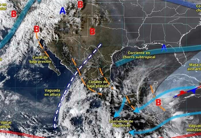
These conditions are associated with the approach of a cold front to the northwest of the country; low-pressure troughs over the interior of the country and the Gulf of Mexico; atmospheric instability; and the influx of moisture from both coasts.
abo/jav/npg/las